Lake Level Management Program
The Lake Level Management Program has been very impactful to date and continues to be critical to longer range protection of our shoreline. For the last 30 years, not enough effort has been made to comply with court ordered lake levels and the enforcement of these rules has been weak in part due to the public's acceptance that destructive lake levels are just part the Black Lake experience. The goal of the BLPS is to challenge that apathy toward the problem and to lay out a more equitable and more effective set of methods to anticipate and avoid destructive lake levels and exposure during the spring melt. To do this, we need our community to understand the controllable and uncontrollable factors in managing lake level and to make their voices known.
The BLPS is budgeting $5,000 for 2020
The BLPS is budgeting $5,000 for 2020
Spring 2019 Results
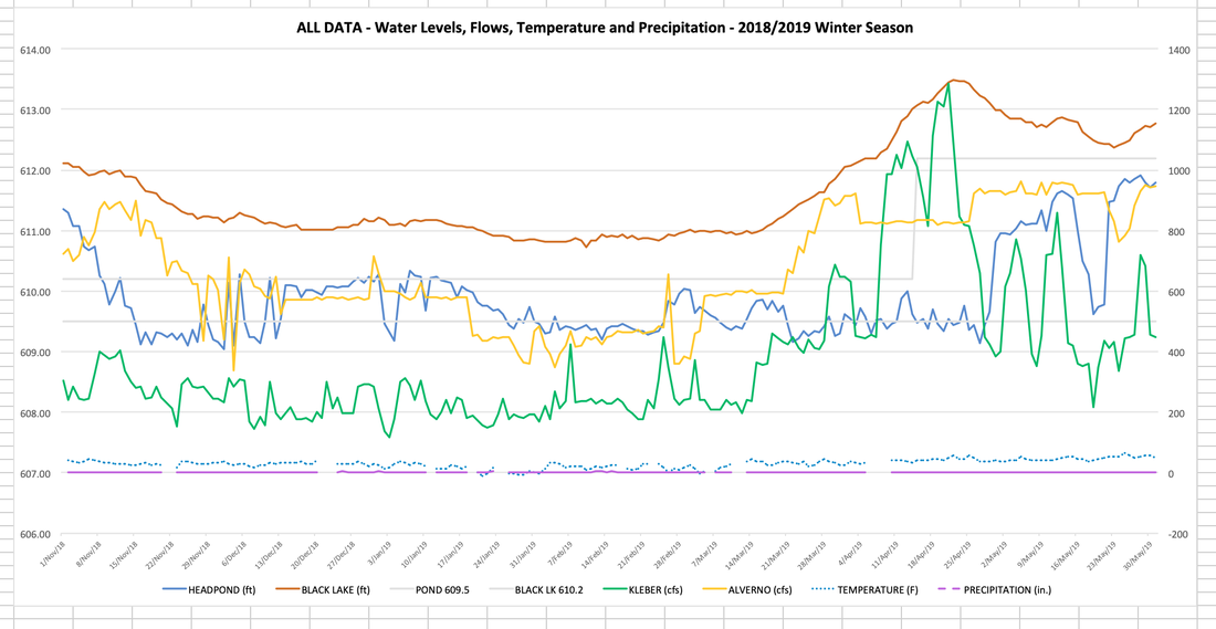
The graph below shows the dynamics of factors that affect lake level rise each spring. It shows that in November of 2018, the lake level (red line) started it's decline toward the court ordered winter level of 610.5 feet above sea level in response to opening the dam and increasing the Alverno dam flow (yellow line) to spill more water than is able to pass through Smiths Rapids. This results in the lowering of the head pond level (blue line). The effect of precipitation is represented by the rate that the Upper Black River flows over Kleber Dam (green line). This line gives us an indication of the net effect in our watershed of water reaching the lake from rain, melting snow, saturation into the ground, evaporation, etc. You will note that the green line was relatively stable through February and that allowed the lake level to stabilize near 610.8 feet above sea level. In mid-March, the inflows to the lake (green line) started to increase and they spiked sharply in mid-April. This was caused by heavy rains and ground saturation that affected our whole region. This caused the lake level (red line) to climb well above the target summer level of 612.2 feet above sea level as water entered the lake much faster than physical limits of the outflow through the bottleneck at Smiths Rapids on the Lower Black River. The elevated lake levels could have been shorter in duration, but the outflow was reduced by raising the head pond. This created a long period of high water that lasted well into June. We were lucky to not have major wind and storm events during that time which would have led to even more erosive energy.

|
2019 ACCOMPLISHMENTS
After what had been a disastrous spring of 2016, the stakeholder team put together a protocol to be followed for the spring of 2018 that focused on head pond levels to more proactively drain the lake. Even in the presence of higher precipitation than in 2016, the spring of 2018 passed without incident. The BLPS proposed an extension of the rules in place for 2018, and the BRLP/dam operator proposed a weakening of the rules followed in 2018. Unexplainably, the other stakeholder groups (Cheboygan County, DNR, DEQ, and BLA) abstained from any strong position or conclusion from the outcome of the test and in the end agreed to the BRLP proposal and against the BLPS proposal. The BLPS engaged with the Federal Energy Regulatory Commission (FERC) to enter a Dispute Resolution process between the BRLP and the BLPS. In the end, the BLA backed the BRLP proposal. The DNR met with the BRLP and, in the end, authorized their proposal over that of the BLPS. The BRLP proposal included the raising of the head pond in April (when our exposure is the greatest). This agreement opens the door for more years of extended periods of high lake levels in the spring if not reversed. |
|
2020 PLANS (FUNDING NEEDS ARE $5,000)
Our goal in 2020 is to gain acceptance of a protocol that includes urgent response to rising lake levels in the spring. Our Project Leader, Rick Scherer, has engaged the US Geological Services (USGS) Supervisor of Hydrology to weigh in on the importance of a low head pond through the spring. The USGS has agreed to this and Cheboygan County will lead the interactions with the USGS. In addition, we are engaged with the DNR to define what constitutes a successful year after considering weather patterns and dam operations. We have proposed a way to quantify success in a measurable, verifiable way, and are working with the DNR to gain acceptance of this model. We hope that this will create a more objective approach for the stakeholder team decision making. We are promoting a new protocol for adoption by the full stakeholder team in light of these activities and the improved understanding of the hydrology of our watershed. We would like to reserve $5,000 to contribute to services that the USGS may be required to charge Cheboygan County to verify their positions. At this point, we don't know what the cost will be, what grant money may be available, or what general funds may be available from state and local agencies. We would simply like to have some contribution to make to the effort when proposed. |

